Volcanism
Burleigh Headlands is 80m above the surrounding area and was created because of a natural formation which was a volcano from Mt Warning that erupted around 25 million years ago. Flowing lava reached the shore in the area to create Burleigh Headland.
Rock Type
Geological processes that shaped the region resulted in a variety of different rock types, influencing the landscapes, vegetation types and animals. The rock type at Burleigh Heads were created by the volcano erupting, the type of rock is basalt.
Weathering, Erosion and Deposition
The weather at Burleigh Heads was a 4 - 6 (Windspeed Knots) or a 2 (Beaufort Force) on the Beaufort Scale which is a Light Breeze. The wind direction was South. This had an effect on the waves at this time, the waves were 0.5m or 1 foot waves in surfer terms. These were unable to cause erosion. Although there was still erosion from the 2013 storms. Rips were also found around the rocks from the weather. However the waves caused deposition all along Burleigh Beach.
Annotated Photograph
This is an annotated photograph of the Burleigh Headlands area. It is labelled with High, Medium and Low density houses, recreational, commercial, open land and public places.
|
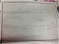
Field SketchThe image above is a field sketch of the view from the Burleigh Headland. It shows the rocks below, the beach, Burleigh Heads and Southport,
|
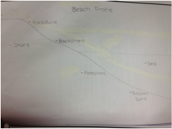
Beach ProfileThe image shown above is a beach profile of Burleigh Beach. Its represents the formation of the beach and shows the erosion caused from storms in the recent years.
|
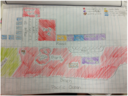
This is an annotated map of Burleigh Heads. It's the area along the beach. It features low, medium and high density houses, parks, restaurants, cafes, bathrooms and a SLSC. It also shows the more known geomorphic processes, Burleigh Heads National Park and Burleigh Beach.
